ファイル:Peering into the Pits of Telfer Mine (153079).jpg

概要
| 解説 |
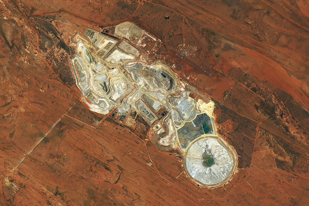
English: In the arid outback of Western Australia, miners have excavated rust-colored soil to reach the precious minerals below. The open pits and ponds of Telfer mine can be seen in this image, captured by the OLI-2 (Operational Land Imager-2) on Landsat 9.
Telfer mine is located about 400 kilometers (250 miles) southeast of Port Hedland, on the land of the Martu Indigenous people in the Great Sandy Desert. The soils have a reddish tint from the iron oxides that have accumulated from millions of years of weathering. This part of Western Australia is known for being rich in natural resources, including petroleum, iron ore, copper, and certain precious metals. Beneath the soils, veins of gold and silver run through sedimentary rocks, such as quartz sandstone and siltstone, that formed during the late Proterozoic, about 600 million years ago, when much of Australia was under water. The mine is comprised of open pits and underground operations (not visible) where ore is mined, as well as ponds where mining waste is managed and stored. Shadows are visible on the terrace-like benches within the open pits on the north side of the mine. These benches support work equipment and catch material from falling debris. On the southern end of the mine, impounded ponds store mining byproducts, or tailings. Once minerals are mined and processed on site, they are trucked to Port Hedland and exported to various smelters, mostly in East Asia. Next to the mine lies housing for a small community, which includes an airport. Telfer is one of the most productive gold mines in Australia. In 2023, it yielded 349,000 ounces of gold. NASA Earth Observatory image by Michala Garrison, using Landsat data from the U.S. Geological Survey. Story by Emily Cassidy. |
||
| 日付 | 撮影日:2023年12月15日 | ||
| 原典 |
Peering into the Pits of Telfer Mine (direct link)
|
||
| 作者 | NASA Earth Observatory image by Michala Garrison, using Landsat data from the U.S. Geological Survey. Story by Emily Cassidy. | ||
| Keywords | Human Presence; Image of the Day; Land |


ライセンス

|
このファイルはアメリカ航空宇宙局(NASA)によって作成されたものです。NASAの著作権の方針では、特記事項が無い場合、NASAの資料はパブリックドメインとなります。 (詳しくはTemplate:PD-USGov、NASAの著作権の方針について(英語)又はジェット推進研究所(JPL)の画像使用に関するガイドライン(英語)をご覧ください。) |
 |
 |
注意事項:
|
|
|
この画像およびメディアは、アメリカ合衆国内務省の実務機関であるアメリカ地質調査所に属する者が職務上作成した著作物のみで構成されているため、アメリカ合衆国国内でパブリックドメインの状態にあります。詳細についてはUSGSの著作物に関する取扱い(英語)をご覧ください。
|
 |
ファイルの履歴
過去の版のファイルを表示するには、その版の日時をクリックしてください。
| 日時 | サムネイル | 寸法 | 利用者 | コメント | |
|---|---|---|---|---|---|
| 現在の版 | 2025年12月9日 (火) 08:23 | | 1,039 × 693 (856キロバイト) | wikimediacommons>OptimusPrimeBot | #Spacemedia - Upload of https://eoimages.gsfc.nasa.gov/images/imagerecords/153000/153079/teflermine_oli2_20231215_lrg.jpg via Commons:Spacemedia |
ファイルの使用状況
以下のページがこのファイルを使用しています:
